Sea kayakers planning a trip don't really need to predict sunshine, rain, temperature or humidity. Even the sea state and ocean swell are seldom important except at an exposed beach. But we do need to know the likely strength and direction of the wind. See Beaufort Scale For Kayakers.
A professional weather forecast gives accurate regional predictions but weather can vary quite a lot over a distance of just a few miles, especially when a cold front is passing overhead. There is a lot to be said for "nowcasting", which means using what you can personally see, hear and feel to predict what is about to happen locally. If you get into the habit of keeping an eye on the sky you can draw useful conclusions from local wind, cloud and atmospheric pressure.
Prediction from local observations
Look to windward for a good idea what weather you will experience in the next 30-60 minutes. Dark clouds and rain usually mean strong winds. However strong winds also come under cloudless skies so it is worth knowing more.
The origin of wind
Global winds
Some of the winds we experience are part of a planetary pattern which includes the Roaring Forties and the Trade Winds. See Global Circulation.
Low and high pressure systems
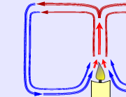 When air is heated, it expands and rises. At the bottom of any column of rising warm air is a zone of low pressure. From all around, cooler, denser air flows towards it and is sucked upwards. This familiar process of convection happens over a candle flame. It happens over a field of wheat on a sunny day, creating small fluffy cumulus clouds and thermals for buzzards and glider pilots.
It may happen over half an ocean if cold water is penetrated by a warmer current. Air picks up warmth from the warmer water, expands, rises in a column, and cools at altitude until the moisture within it condenses into clouds. The Coriolis effect of the Earth's rotation makes the rising column of air rotate like water going down a plughole. Surface winds are created as air is sucked into the base of the column. This weather system is called a low. Technically it's one example of a cyclone. Low pressure systems are strongly associated with clouds and rain.
A high pressure system (air descending from high altitude, high pressure, usually fine weather) is known as an anticyclone.
Local winds
Some winds are caused by local geography. In temperate climates with no nearby mountains, this kind of wind seldom exceeds 5 knots, so a local wind is not enough to affect a kayak trip on its own. However, it can turn a Force 3 wind into a Force 2 or 4.
Sea winds, also known as inflow winds, arise when the land heats up during the day. The air over it starts to rise, drawing in cooler air from the sea. At night the land temperature falls below that of the sea and the wind reverses.
In temperate climates during clear, calm summer weather weather there is often a sea breeze of 5 knots by mid-afternoon.
Sea winds are strongest in the tropics but they can be powerful in places along the coast of any large land mass. According to the US Pilot Guide to the west coast "heating of the North American continent helps draw air into the Strait of Juan de Fuca. This sea breeze helps reinforce the prevailing [south-westerly] flow and results in winds up to 30 knots in the late afternoon".
Valley winds occur where a range of mountains stands alongside a valley. On a hot summer morning, the sun rapidly heats the air above the upper slopes of the mountain, which become warmer than the valley. An anabatic wind starts to blow up the valley and up the sides of the mountains. Anabatic winds are usually quite gentle.
Later in the day, air temperatures in the valley increase above those on the mountain tops. Relatively cold, dense air sinks into the valley and carries on descending, down the valley towards the sea as a katabatic or fall wind. Especially if they come from a glacier or snow-covered mountains, katabatic winds can be powerful, causing sudden fierce winds far out to sea and making life interesting for sea kayakers in a river mouth.
On the coast of British Columbia, Squamish winds sweep down fjords to the sea. In winter they arrive at the sea doing 35 knots and sometimes a lot more. In the area of Juneau, Alaska, the cold descending Taku wind can be powerful.
In Europe, probably the best-known katabatic wind is the Mistral which is created by cold air from the Alps sinking into the Rhone valley, racing down the Rhone, through Avignon and Marseille, and south out to sea. Other similar winds are the Bora which blows from the Balkans south-west over the Adriatic, and the Meltemi which blows south over the Greek islands. They tend to start in the early afternoon and blow at Force 4-7 until sunset. The Sailing Directions for the North Atlantic & Mediterranean published by the National Geospatial-Intelligence Agency list thirty-seven other winds of this sort in the Mediterranean alone. Last time we looked, the Sailing Directions could be downloaded from this page on the www.nga.mil site.
Föhn winds. Not a problem for sea kayakers, but worth mentioning. Where mountains stand by the sea, it is well known that an onshore wind will be forced upwards until it sheds its moisture as cloud and rain. If the prevailing wind is onshore, the usual weather on a mountainous coast is overcast, wet and cool and the natural landscape is forest, boulders shaggy with moss, frequent steep rivers and patches of bog. However if the wind blows offshore the coast may be warm and dry because of föhn winds. Having already been forced up over the mountains from inland, wind reaching the sea is dry and perhaps as much as 10°C (18°F) warmer than on the other side of the mountains.
Atmospheric pressure
We live at the bottom of a deep sea of air which imposes on us a pressure of about 14 pounds per square inch.
Atmospheric pressure is measured with a barometer and recorded in millibars (mb), otherwise known as hectoPascals (hPa). The first barometer was a long glass tube sealed at one end, filled with mercury and turned upside down. Its inventor, Torricelli, found that average atmospheric pressure at sea level would support a column of mercury nearly 30 inches high in the tube, and atmospheric pressure is still occasionally stated in inches of mercury (inHg).
Average pressure at sea level is about 14 psi, or 1 kg/cm2, or 1 bar. It is defined as 1 atmosphere which is 1013 mb or 29.92 inHg.
Low pressure systems arise when warm air starts to rise above colder air alongside. Air moves constantly into any low pressure system from neighboring areas of higher pressure, in the form of wind. The greater the pressure difference, the stronger the wind.
The pressure at the center of a deep low may be 940 mb, a pressure difference of 70 mb which will create strong winds or gales. If the atmospheric pressure where you are is falling rapidly, it is a warning of imminent bad weather. Weather forecasts for shipping state the rate of pressure change, usually as the amount by which the pressure has fallen or risen over the last three hours. A pressure change of 0.1 to 1.5 mb in that period means isobars quite far apart, winds gentle or moderate. A decrease in pressure of more than 6 mb in three hours means isobars close together, winds strong and possibly getting much stronger. Some expedition sea kayakers keep an eye on the rate of pressure change by wearing a wrist altimeter, which is just a digital barometer.
High pressure systems also create wind but the greatest pressure is seldom more than 1030 mb, a pressure difference of only 15 mb. See The Classic Anticyclone below.
Just as contour lines on an ordinary map indicate a hill or valley by joining points of equal height, so the isobars on a meteorological map indicate high and low pressure systems by joining points where the pressure is the same. If contour lines on a map are very close together they indicate a steep hill, with the slope descending at a right-angle to the contour. Isobars very close together indicate an intense pressure system with strong winds.
We might expect the wind to blow at a right-angle to the isobars, directly towards the lowest pressure. In fact it blows nearly parallel to the isobars. This is caused by the rotation of the Earth, and can be seen in the swirling spiral shape of clouds on satellite photos of a low. In the northern hemisphere, the wind blows counterclockwise round the center of a low and clockwise round the center of an anticyclone.
Global circulation
Heated by the sun, air at the Equator constantly rises and spreads out towards the Poles. It cools at high altitude, descends at the Poles and blows back towards the Equator.
The convection pattern resembles that over a candle flame, but the Earth's rotation and differential heating of land and sea mean that it is complex and has seasonal changes. A lot of air from the Equator cools and descends long before it reaches the Poles, along parallel lines about 35 degrees north and south of the Equator. The pattern is further distorted by differential heating of central Asia in summer, resulting in monsoons. The result looks something like this. High pressure is shown in red, low pressure in blue, and continuous winds in black. The Poles are not shown.
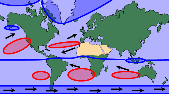
There is always low atmospheric pressure at the Equator. There is always high atmospheric pressure at the Poles and in northern Canada. There are belts of high atmospheric pressure along the 35 degree lines or Horse Latitudes. Constant high pressure exists in the Atlantic around the Azores and St Helena; in the Pacific west of California and Chile; and west of Australia.
Winds blow constantly from high pressure to low pressure. Because the Earth rotates, these winds do not blow directly north-south but at an angle. This accounts for the westerly winds of the Roaring Forties, north Atlantic and north Pacific, and the easterly Trade Winds each side of the Equator.
Convection currents are powered by heat. The more heat, the more convection. The more convection, the stronger the winds. Winds can change ocean currents, and they can block the weather systems we're used to, such as the Indian monsoon. That is basically why global warming means there will be more extreme weather events in future. For example, gales, floods, droughts, tornadoes and hail. And that means crop failures, forest fires, bigger deserts, flood damage to towns, and loss of farmland. It's the price of a globalised consumer lifestyle, and it's a price that future generations will find it difficult or impossible to pay.
Air masses
High altitude air descending to the Arctic is cold and will still be cold when it reaches Canada or Europe. Unless it passed over an ocean on the way, it will also be dry, making it a "polar continental" air mass.
High altitude air descending into the Azores High or the Pacific High gets warm and moist when it reaches sea level, which makes it a "tropical maritime" air mass.
In the northern hemisphere, polar air masses spread out southward until they meet a northbound tropical air mass. Because of their different heat and humidity, they don't easily mix. Warm tropical air tends to ride up over cold, dense polar air. The line where they collide is parallel to the Equator at about the latitude of the US/Canadian border, Newfoundland and England. It is called the polar front, and it is unstable.
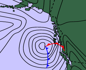
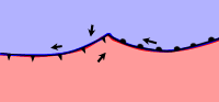 Rather than stay as a straight line, it often develops notches or "frontal waves". In the northern hemisphere (illustrated) a swirl of cold air penetrates towards the Equator and warm air is carried north. The black arrows show the direction of local winds at the front.
Where the tropical air meets cold Arctic air it rises, cools down and its moisture condenses into clouds. The lines where the warm and cold air masses meet are called fronts and there you will find cloud and wind. At a warm front, warm air is rising gently over cold air. On a weather map, a warm front is conventionally marked as a line with semicircles. At the cold front, cold dense air is wedging itself vigorously under warm air. This is marked as a line with triangles. If the cold air mass slides underneath and lifts the warm air right off the ground you have an occluded front, shown on weather maps as a line of alternate triangles and semicircles.
For most of us in temperate regions, the weather consists of one front after another. If a frontal wave deepens, the warm moist air may become the "warm sector" of a classic low. The Earth's rotation causes lows in the temperate latitudes of the northern hemisphere to spin anticlockwise and move slowly to the east producing wind, cloud and rain.
Coastal weather in North America
Climate is what you expect for the season, weather is what you get on the day.
 |
Climate
Cool currents on the west coast and mainly warm currents on the east mean there is a marked difference in sea temperatures in similar latitudes.
Thanks to the cool Alaska and California currents, most of the west coast has a temperate climate with cool summers and warm winters. Even north of Vancouver, snow seldom lies at sea level in winter.
The Great Lakes have a fairly dry "continental" climate with hot summers and cold winters.
The eastern seaboard has a range of climate from sub-tropical in Florida where the Gulf Stream runs alongside and onshore winds are very often "tropical maritime" from the Azores High, to sub-arctic in Newfoundland which is dominated by the cold Labrador current. |
Weather
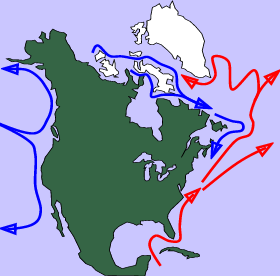
There are free authoritative downloads about regional weather patterns on the Internet. For the USA, you can download NOAA Coast Pilots and for Canada there are NAV CANADA Local Area Weather Manuals. We think it's worth giving a very basic introduction to weather systems, starting with the fact that in North America they travel west to east.
S. Alaska & British Columbia. See NAV CANADA's Weather In British Columbia which you can download here, and the Guide to Interpreting Environment Canada's West Coast Marine Forecasts which you can download courtesy of the Oregon Ocean Paddling Society. Last time we looked the link was here.
The whole of the Inside Passage from Seattle to Skagway gets some shelter from winds and swell behind a chain of islands. The coast in the lee of mountainous Vancouver Island is particularly sheltered. The island also creates a rain shadow so that annual rainfall of 3 meters in Tofino on the west coast becomes only 1.15 meters at Nanaimo on the east.
 There is almost constant low atmospheric pressure over the Pacific ocean west of BC and Alaska, known as the Aleutian Low.
A succession of low pressure system crosses the ocean and reaches the coast. Lows are deeper in the Gulf of Alaska. Coastal lows reaching the southern and central BC coast are less predictable and often deepen suddenly into bombs as they reach the coast. They can change in as little as 9 hours from a very weak system to a severe storm.
Winters are stormy, with swell running more than 12 feet high for 20% of the time and 20 feet for 4% if the time. However in summer the Pacific High extends north to the latitude of Vancouver Island, resulting in stable weather for southern BC and sending low pressure systems and their strong winds north into the Gulf of Alaska and northern BC.
On summer afternoons, the land heats up more than the sea and there are significant inflow winds up most inlets and valleys. Inflow winds can be strong in the Strait of Juan de Fuca, Portland Inlet, Howe Sound and in the Hope area.
Inland temperatures are high in summer and low in winter but at the coast they are moderated by the ocean. Surface sea temperatures around Vancouver range between about 60°F (16°C) in summer and 40°F (4°C) in winter. Even in midwinter, air temperatures in southern BC seldom drop far enough to give more than a few days of snow at sea level.
Washington to California. Detailed weather description in US Coast Pilot here. There is almost constant high atmospheric pressure over the ocean between Hawaii and California (the Pacific High) which means a stable coastal climate. It shelters the California coast from the wind, but the entire west coast is the lee shore for the Pacific ocean so expect big waves on exposed sections. The Sea of Cortez / Gulf of California is sheltered by the Baja Peninsula.
Cool currents run along most of the Pacific coast, keeping surface sea temperatures generally within the range 45 - 68 °F (07 - 20°C) all year. Surface sea temperatures in parts of southern California can reach 72°F (22°C) in summer.
Winter gales and rough seas are common on the north and central sections. Strong winds and high seas can be expected several times a month in winter in northern California but are rare south of Los Angeles.
North from Oregon the coastal climate is wet, especially in winter, as the prevailing winds have passed over the ocean and picked up a high moisture content. The Pacific high deflects eastbound low pressure systems north to British Columbia and Alaska.
Great Lakes. Detailed weather description in US Coast Pilot here and NAV CANADA's The Weather In Ontario & Quebec here. The climate is continental (hot summers, cold winters) but moderated by the presence of the Great Lakes themselves.
This is one of the most active areas for migratory weather systems, and the weather changes very fast with the arrival of lows originating anywhere from the Gulf of Mexico to Alberta. See The Classic Low, below. The Great Lakes basin lies very near the polar front so lows import air masses alternately from the Arctic and the Gulf of Mexico. The origin of the wind determines its warmth and its moisture content and makes the difference between a good day and a bad one.
Thunderstorms are quite common in July and August, and for much of the winter the Lakes get fog at warm fronts and strong winds at cold fronts. Lows particularly affect the lower lakes in spring and the upper lakes in the fall, when there may be intense storms and low temperatures with the arrival of a polar air mass. The US Coast Pilot comments "Autumn is dangerous; clear crisp days are often interrupted by rapidly intensifying low pressure systems whose gale-force winds can whip tumultuous seas..." There is surfing around the shores of the Lakes on waves generated by local winds, especially in the colder months.
Water temperatures in summer are highly variable. In Lake Superior, except for shallow bays and beaches, the surface water temperature is usually below 57°F (14°C) even in summer. Lake Michigan is a few degrees warmer. Apparently the western end of the shallow Lake Erie can reach 75°F (24°C).
In mid-winter, water temperatures are 32-39°F (0-4°C). Polar air masses frequently reach the Lakes, causing very low air temperatures and sometimes a low layer of "sea smoke" fog. Shore ice can be expected around all the lakes and Lake Erie can freeze over altogether.
Eastern seaboard. Detailed weather description in US Coast Pilot here. As with the Great Lakes, much of the east coast is on the track of low pressure systems moving west to east and producing changeable weather.
Temperatures on land are moderated by the presence of the ocean. Sea temperatures at Miami beach are 70°F (21°C) in winter and 86°F (30°C) in summer. Off New York they are 36°F (2°C) and 72°F (22°C). In Maine they are 34°F (1°C) to 62°F (17°C) or higher in sheltered areas. The cold Labrador current causes extensive sea ice as far south as the Gulf of St Lawrence from the first half of December until the middle of April. Some midwinter shore ice can be found in some sheltered inlets as far south as Chesapeake Bay.
The classic low
 Where air masses of different temperature and humidity meet, fronts arise.
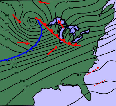
Over north America there is usually a chaotic pattern of warm and cold fronts, all travelling east. Sometimes there is a fully-developed low pressure system like the one shown approaching the Great Lakes on this weather map.
As the earth rotates, low pressure systems in the northern hemisphere spin counterclockwise and move slowly to the east (blue arrows), producing wind (red arrows), cloud and rain.
The speed and direction of wind in the warm sector gives a good indication of the speed and direction of travel of the whole system. It can move east at anything from zero to 60 knots but usually travels at 15 to 20 knots.
A low pressure system is a complex three-dimensional shape. Surface winds are just the bottom layer of it. The isobars on a weather map show what is happening at sea level but above that is a column of rising air. Into the base of this is drawn a swirl of warm, damp air from the south. This makes up the warm sector of a low pressure system. On a weather map, the warm sector classically takes the shape of a rose thorn. In the northern hemisphere the eastern edge of the warm sector is called the warm front, and the western edge is the cold front.
Each front forms a line from the center to the outside edge, usually extending east and south from the center of the low pressure system. At a front you find cloud, rain and wind. If the center of a low passes to the south of you, you may still experience cloud and rain but you will not get the strong wind and rapid change of wind direction associated with a cold front.
What do you feel and see as the fronts of a low pressure system pass by? If its center is between you and the Pole you will see a characteristic succession of clouds. On this diagram the warm sector is shown in pink; the warm front is the shallow gradient on the right; the cold front is the steep gradient on the left with the thunderstorm; and the blue arrow shows the direction in which the low is travelling. The horizontal scale is 1500 miles (2500 km) and the exaggerated vertical scale is 25,000 feet (7600 meters).
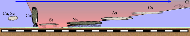
The classic signs of an approaching warm front are:
• Cirrus clouds (abbreviation Ci) and pressure starting to fall. Cirrus are high-altitude clouds of ice crystals, appearing as white wisps and streaks ("mares tails") against a blue sky. They are up in the jet stream, probably 500 miles or more ahead of the warm front. Low pressure systems travel in the same direction as the jet stream, and the streaks of cirrus point back to the center of the system. In the northern hemisphere, if you stand with your back to the surface wind and the cirrus clouds show that the center of the approaching low pressure system is to your left, the weather is about to deteriorate. This is the "crossed winds rule". Over the next 24 hours you are likely to see a continued steady fall in atmospheric pressure accompanied by...
• Cirrostratus (abbreviation Cs). Below cirrus but still quite high. Cirrostratus covers most or all of the sky in a very thin layer through which the sun can often be seen. Then...
• Altostratus (abbreviation As). Below cirrostratus. Gray, overcast weather, perhaps drizzle. Then...
• Nimbostratus (Ns). Below altostratus. Low or very low rain clouds covering the sky in a thick gray or dark layer. On a television weather forecast, you will often see a north-south belt of continuous light rain 50 miles wide, slowly heading east. This is the warm front. As it goes over you, the wind veers (shifts in a clockwise direction). Typically, a south wind becomes a west wind.
Between the warm front and the approaching cold front is the warm sector. This is a mass of warm moist air, steadily losing its heat to the surface and to the cold air on each side. As it does so, it cools down and sheds its moisture as haze, drizzle, low flat gray cloud (stratus or St), and mist or fog which is the same thing but at ground level.
After 1 to 12 hours the cold front arrives. You may see it coming, as a wall of dark cloud on the western horizon. The higher and darker the wall, the more violent the wind and rain. On the image above, it has just reached Minneapolis where they can expect:
• Cumulonimbus (Cn). Tall, thick clouds which are low and often dark at the base. Expect an hour or so of heavy rain and strong winds. There may be tall, black clouds with thunder and very strong, gusty line squalls at sea level. As the front passes overhead, the atmospheric pressure starts to rise again, sometimes sharply. The air temperature drops. You will probably notice a sharp change of wind direction. Again, the wind veers, typically from south-west to north-west. Except for the rain, visibility improves. Then...
• Cumulus (Cu), cumulonimbus, stratocumulus (Sc). After the cold front there is often an unstable period of low thick cloud, wind and showery rain. Then...
• Altostratus. Gray, overcast, showery weather with an increase in atmospheric pressure. Then...
• Cirrostratus. And maybe blue skies.
Classically, atmospheric pressure will steadily rise for 24 hours after the cold front passes and then settle at a little more than 1000 mb. If it rises only slightly and then starts to go down, probably another low pressure system is in the way.
The classic anticyclone
On a weather map, a high may be as wide as a low pressure system but its isobars are usually further apart, indicating a smaller pressure difference and less wind. There is no warm sector, no fronts, and wind created by an anticyclone blows the opposite way to that in a low pressure system - outwards. In the northern hemisphere, winds in an anticyclone blow clockwise. In the image above, an anticyclone is sitting over Florida.
High pressure is often associated with long periods of calm dry weather. In winter, this classically means gray and overcast weather but in summer it means clear, sunny skies with a slight haze. Occasionally it brings fog in coastal waters.
A high pressure area established in a particular location will affect the weather by deflecting low pressure systems so that they fade out or go elsewhere. A high pressure area often establishes itself temporarily over one part of the country. There is almost always a high pressure area in the Pacific west of California which dominates the weather for the whole west coast.
Fog
Fog consists of water droplets condensing out of the air, which happens when relatively warm, moist air is chilled. It can be defined as cloud at ground level. Mist reduces visibility to between 1000 metres (0.62 miles) and 5000 metres (3 miles); fog reduces it to less than 1000 metres, and thick fog may reduce it to less than 15 feet.
Fog happens when particularly warm moist air heads away from the tropics and meets cooler air or water. More often, it happens when air at an ordinary temperature and humidity is chilled. This can happen in many ways. Hill fog is common in the mountains, where wind is chilled when it is forced upwards by the rising ground. Fog in the lowlands occurs mainly in autumn and winter when clear skies allow the land to cool overnight. This "radiation fog" may blow a mile or so out to sea. However it tends to dissipate in contact with the sea, so there may well be good visibility a few yards offshore, and in any case it generally burns off by mid-morning.
True sea fog happens when moist air is suddenly chilled by contact with cooler water. It is common where a cold ocean current runs along a coast, as in Newfoundland and right along the Pacific coast. On the California coast it occurs when seasonal winds cause an upwelling of cold water. Sea fog can happen at any time of year and a fog bank can arrive at 30 mph on a warm, still day under a blue sky.
Climate change
There's no good time to talk about bad things that are coming - unless you still have time to prevent them, or time to prepare for them.
Here are some facts that everybody on the planet should know:
- Global warming is happening right now; the only doubt is about what's causing it.
- It's making the whole planet slightly warmer. So far, about 1.7° fahrenheit since the start of the industrial period.
- "Global warming" does not mean "It'll be a bit warmer. That'll be nice."
- Global warming of 3.6°F is likely to cause catastrophic and irreversible climate change.
- Climate change is already happening, and it's already severe for some people.
"Global warming" sounds quite nice, doesn't it. But it doesn't mean your home is going to get slightly warmer. Some parts of planet Earth will get slightly warmer, but some parts are going to get so hot they burn, like Australia in January 2020. Some parts will be drowned by rising sea levels, some will no longer have enough water for farming, and some will freeze. Hundreds of of millions, perhaps billions of people will have to migrate or die.
Global warming could even cause the USA and northern Europe to freeze, like a slightly slower version of that disaster movie "The Day After Tomorrow". How could global warming possibly make a continent colder? By changing ocean currents. The Gulf Stream is a warm current,like a river flowing in the sea. It's about 60 miles wide, 2500 feet deep and flows at 5 knots in places. That's some river. And it's warm water, too, heated by the tropical sun. It flows from the Caribbean, up the east coast of the USA and then heads out into the north Atlantic in the general direction of Britain, before turning south and flowing past Spain and north Africa, then back towards the Caribbean to start again. Click here for a map of these currents, and in general see Ocean Currents.
An arm of the Gulf Stream called the North Atlantic Current (NAC) or the North Atlantic Drift warms the whole north Atlantic. A lot of this heat is transferred into the winds that blow from north America to northern Europe. It's this relatively warm wind that stops northern Europe freezing for 6 months every winter. Parts of Britain are further north than Moscow; they're as far north as Hudson Bay in Canada, where the sea freezes every year from December to June. The indirect effects of the Gulf Stream are the only thing that stops the sea around Britain, the Netherlands and Scandinavia from freezing.
The Gulf Stream and the North Atlantic Current (NAC) are part of the the Atlantic Meridional Overturning Circulation (AMOC). The AMOC itself is part of the "global conveyor", ocean currents that move heat around planet Earth. Global warming, by melting the Arctic ice, is sending more cold water southwards between Canada and Greenland. This strengthens the cold Labrador Current. This has the power to deflect the Gulf Stream further south, cooling the north Atlantic and turning Scandinavia, northern Europe, Canada and parts of the USA into a freezer. This is a real possibility. The AMOC has already weakened in the last 20 years. Researchers at Utrecht University predict a 15% chance of NAC shutdown in the next hundred years.
Both NAC slowdown and shutdown have already happened during human times. About 12,800 years ago it took only two or three years for northern Europe - and large parts of north America - to get covered in snow and ice. Everybody in the northern half of both continents either moved south or died. This very cold period is called the "Younger Dryas" or the "Big Freeze", and it lasted more than a thousand years. It is believed to have been caused by NAC shutdown. NAC slowdown, caused by rising temperatures in the northern hemisphere, is believed to have caused the "Little Ice Age" that hit north-west Europe and parts of north America. This lasted nearly 500 years, starting in about 1430. The Norse population of Greenland all left or died; the population of Iceland dropped by 50%; famines killed 30% of the population of Finland, 20% in Estonia, 10% in Norway, Sweden and France, with malnutrition across much of Europe and north America; wild and domestic animals died; there was disease, violence and unemployment; extreme weather caused massive flooding and coastal erosion in Denmark and Germany; there were repeated snowstorms in Portugal; clothing styles changed and became warmer; more efficient fireplaces and chimneys were installed in homes and public buildings; there was a rise in religious fundamentalism.
Ice has often covered Canada, the northern USA and northern Europe in the past, even during human times. Just Google "Quaternary glaciation". The ice comes, the surviving humans move south. The ice goes, humans come back. And if the ice goes, that's not so great either. If all the polar ice melts, the sea level rises. By an estimated 216 feet, eventually.
Because there are 7 billion of us, with a passion for energy, and the machinery to extract and burn coal and oil, we have the power to break the current climate. What we don't have is the power to fix it when it's broken. You can't argue with climate change, or say it's fake news or that it's violating your constitutional rights. You can't arrest it, or spy on it, or impeach it, or protest about it, or bomb it, or deport it, or send it to live on a reservation or in a refugee camp, or carry out counter-insurgency on it, or build a wall against it. It doesn't care about careers, or fashion, or Twitter, or healthcare, or religion, or economics.
We have the power to cause a climate disaster, by releasing huge quantities of carbon dioxide into the atmosphere, and we are doing exactly that, faster and faster. This has already affected the climate and, when it reaches a certain point, major climate change will just start rolling on its own, and it will roll right over us. That's what scientists mean about a tipping-point. Climate change has been quietly minding its own business for thousands of years, but we're waking it up. What it'll do is anybody's guess.
The planet is definitely getting warmer. Few politicians or oil companies try to deny that, but they say it's not because of human activity. They deny it; they are climate change deniers, climate change skeptics. They say "if you want big changes to farming and transport and homes and shopping, you have to prove your case". That's clever, in a dumb kind of way, because (as any scientist, statistician, doctor or lawyer can tell you) it's hardly ever possible to prove anything absolutely. However much proof you collect, there's always a doubt, and there are always inconsistencies in the evidence.
Here's the official scientific word: The Intergovernmental Panel on Climate Change (IPCC) Fifth Assessment Report says "It is extremely likely that human influence has been the dominant cause of the observed warming since the mid-20th century".
"Extremely likely"? Why not just "definitely is"? That's a good question, and it deserves a good answer. "Extremely likely" would not be enough to send you to Death Row for murder. A criminal conviction requires proof "beyond a reasonable doubt". However "extremely likely" would be more than enough for a court to give somebody custody of a child, or make somebody bankrupt, or shut down a company because of a contract dispute.
Judges in criminal cases never ask for proof beyond a reasonable doubt. Because that's about as good as proof ever gets. There are always doubts and inconsistencies and loose ends in any scientific research, in any business proposal, and in any crime. Even if you have a video of the crime, it's open to interpretation. "That's not me, that's somebody who looks like me" or "You can't see it in the video, but he had a knife". But we don't let murderers and child molesters walk around loose just because there's no absolute proof they did it. That would be dumb.
For exactly the same reason, it is dumb to let the planet be seriously damaged by climate change when every farmer, local government and insurance company knows the climate is changing. What goes for court cases goes double for scientific proof where you're dealing with a complex system like the human body. There is no absolute proof that cigarettes are bad for you, or that asbestos gives you cancer, or that jumping off a tall building will kill you. But common sense tells us to avoid smoking, asbestos and jumping off tall buildings. And if the human body is a complex system, a planetary climate system is incredibly complex. Absolute proof is not possible.
Donald Trump, a man who has no scientific training (he has a bachelor's degree in real estate and threatened his school and college with legal action if they ever release his SATs or other grades), says there is no climate problem. "Fake news", he says.
If you're not a professional climate scientist, you have nothing to add to the debate. However it is always possible for a shyster lawyer or a dishonest statistician to find a few loose ends in the climate argument and tug at them. Climate is one of the most complex systems we know; there always will be loose ends. If you're a defense lawyer, it's your job to raise doubts about your client's guilt, to find inconsistencies, to create confusion in the minds of the jury. Dozens of "climate conspiracy" books are in fact written by lawyers and statisticians who are paid to do exactly that. They're paid to write, by oil billionaires and neo-liberal think tanks. It is their job to keep their employers in luxury just a little longer by creating just a little doubt.
Global warming is caused by carbon dioxide. Unlike the other gases in the atmosphere, which let solar energy in and out, carbon dioxide (CO2) lets the sun's heat in - but not out. It lets short-wave solar energy in through the atmosphere and then stops long-wave heat radiation from the Earth getting out again. Like a greenhouse.
Apart from giant asteroid impacts and the activity of the sun itself, carbon dioxide is the biggest factor in all kinds of climate change. It's only a tiny part of the atmosphere; just 0.04% at present. It's because it exists in such tiny quantities that human activities make a difference to the amount. When you're talking about carbon dioxide, there's a big difference between 0.03% and 0.04%. For the last hundred years we have been putting more CO2 into the air by burning coal and oil, and by cutting down forests and raising cattle. And it does make a difference. For most of the last million years, carbon dioxide levels have been between 200 and 280 ppm. The line on the graph goes up (volcanoes and warm periods), then the line goes down (cool periods). Since the start of the Industrial Age, the line has been going straight up, like a rocket heading for outer space. In 2013 it went past 400 ppm. It has since gone past 410 ppm - and despite all the talk by the world's governments, that line is rising faster every year.
This extra carbon dioxide does two things. First, the greenhouse effect makes the planet slightly warmer, and this changes local climates and causes extreme weather.
Climate change is bad. Our homes, travel, jobs and food depend on predictable temperatures, humidity and rainfall. Almost any kind of climate change is bad, almost anywhere. Farmers need to know what kind of climate they'll have next year and the year after and five years after that. With fast climate change, you have entire vegetation systems dying in conditions that have suddenly become too hot or too cold, too dry or too wet, too windy or too dusty. Your trees die; your crops won't grow; your houses are designed for conditions that no longer exist; your ski resort from ten years ago is now snowless, or there's so much snow in your backyard that you can't get the door open; deserts spread; half of Australia burns out of control; sea level rises. If all the ice at the Poles melts, and it is melting fast, sea levels rise by 216 feet. Floodwater will drown not just Venice and a few islands in the Pacific but the whole of Holland, Denmark and half of Britain. Not to mention Florida, the Mississippi valley and the whole eastern seabord of the USA from Houston through New Orleans and Norfolk and New York up to Boston and Halifax. We expected this to take thousands of years, but every new estimate of sea level rises gives a shorter timescale. Early estimates were that sea levels would rise a couple of inches this century; the latest best estimates are for a couple of feet. But that assumes we get serious about controlling the amount of carbon dioxide we produce.
Extreme weather is bad. The air circulating in the atmosphere is like the water circulating in a kettle. Weather happens when there are temperature differences. In other words, weather is driven by heat. Make a kettle hotter and the water boils faster. Make the atmosphere hotter and you get extreme weather events. The roof of your house is ripped off, highways are washed out, there are killer heatwaves in one place, and rain every day for a year in another. Farmland is washed into rivers, or it dries up and blows away. Even a small rise in sea level, combined with a storm surge from an intense low-pressure weather system, can flood a major coastal city.
Even the air we breathe is at risk. Most of the oxygen in the air is produced not by tropical forests but in the sea, by phytoplankton.
So far, seas and oceans have been more affected than the land by global warming, because they have been absorbing a lot of the carbon dioxide from industry, and a lot of the heat from global warming. This is a problem in itself. First, warm water holds less oxygen than cold water. Fish need oxygen to breathe. The amount of oxygen in the global ocean is down 2% since the 1960s and this is happening faster now. Some sea areas around NW Europe have become hypoxic, which means no fish big enough to be worth catching. This trend will continue. Oxygen levels in relatively enclosed seas like the North Sea are expected to decline by 11.5% this century.
Second, carbon dioxide makes water more acid, especially sea water which absorbs carbon dioxide from the air to make weak carbonic acid. This dissolves calcium carbonate. A lot of sea creatures that are essential to the way the sea works, from microscopic plankton up to entire coral reefs, make themselves protective shells from calcium carbonate, particularly in the form of aragonite. As the oceans get more acid, you get "undersaturated aragonite conditions", which means these creatures can't make shells, so they die. Life in the sea collapses. No more shellfish, no more reefs, fewer fish - and much less oxygen in the air for us to breathe. Not to care about what happens to the oceans is not to care about the survival of the human race.
Go to next page for:
• Professional Weather Forecasts